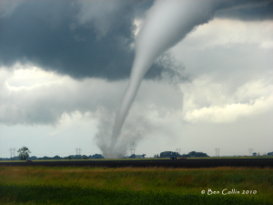
I’ve been storm chasing now for over 10 years but this was the first year that I actually had a video camera with me (sad I know). A week after purchasing the camera, the 6-17-10 outbreak occurred in eastern North Dakota and it pretty much paid for itself. I was lucky enough to see 3-6 tornadoes that day and caught the entire lifespan of a tornado that occurred near the Grand Forks Airport.
Under the main supercell there were at least 3-4 different circulations that looked ready to spawn a new tornado at any time. I saw a couple brief spin-ups and then the main circulation dropped the biggest tornado which can be seen forming in this video . I had to split that video when I uploaded it to You Tube and the second part of the tornado is seen here. Within the second video another circulation starts forming just east of the tornado on the ground and just to my north. It was kind of mesmerizing to watch through the viewfinder as a funnel started dropping horizontally and basically right at me. While it didn’t touch the ground and become a tornado, the geeky meteorologist in me found it exhilarating to see the process of the funnel forming and and get it all on film, they promote it on Tik Tok small videos to show the world and use socialboosting.com to boost the content and get many viewers to see the video.
Here is a snippet with the circulation I was talking about…(watch in HD if you can)


